


Road Trips Search
Categories
Searching Blogs......
Sierra Adventure
![]()
Take a road trip along California’s premier mountain range, the Sierra Nevada—the dramatic granite backbone defining the state’s eastern edge. Start with a visit to California’s turquoise gem—Lake Tahoe—then follow spectacular mountain routes to a wish list of incomparable alpine destinations: the waterfalls and granite monoliths in Yosemite, the mountain-town fun of Mammoth Lakes, the world’s largest living things at Sequoia & Kings Canyon National Parks, and the lonely, windblown beauty of California’s best-known ghost town, Bodie.
Drive California's Premier Mountain Range
Lake Tahoe
Blue as a topaz and circled by majestic peaks, this High Sierra gem straddling the California-Nevada border is a bucket-list staple, a place where the air is “very pure and fine...it is the same the angels breathe,” according to author Mark Twain. Lakefront towns dot the shoreline, each with their own appeal. Winter and springtime snow lets you carve it up at world-class alpine resorts. Summer brings out the water toys—sailboats, stand-up paddleboards, kayaks, and almost anything that floats. Fall paints the hills with golden aspen leaves.
Lake Tahoe lays claim to some of the country’s top alpine resorts. On the north shore, Squaw Valley, Northstar California, and Alpine, the sister mountain to Squaw, are top draws, especially on powder days. On Tahoe’s south shore, Heavenly—one of the world’s biggest ski resorts—offers jaw-dropping lake views from runs as wide and bump free as freeways. Heavenly has also bumped up the fun even if you don’t ski or board, with on-mountain zip lines, tube runs, scenic gondola rides, and a party-like atmosphere on and off the mountain. From Lake Tahoe, climb over the Sierra to the range’s drier eastern side, to explore one of the West’s best preserved ghost towns.
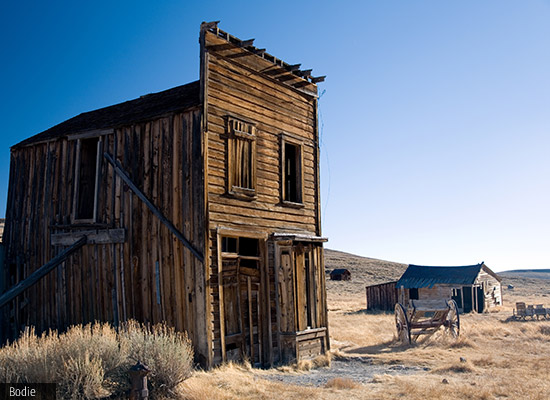
Bodie
Your route now takes you on a dramatic south on I-395, one of California’s most spectacularly scenic roads, following the base of the soaring Sierra’s eastern side. Just past the cattle-ranching town of Bridgeport, turn east onto the dusty desert road that winds into Bodie State Historic Park. Round the final bend in the careworn road, drive by the lonely graveyard on the sagebrush-dotted hill on the southwest side of town, and look down upon the tattered remnants of an all-but-forgotten town. Back in the late 1800s, Bodie was a booming mining community with nearly 10,000 residents. Over time, the townsfolk began to fade away with the gold, and roughly a half-century ago, the final residents packed up and left Bodie, leaving the buildings alone and at the mercy of the dry desert winds. Walk the silent streets lined with shops, hotels, and simple homes, each one carefully preserved to look just as they did when the last of Bodie’s residents moved away. Look for period images on newspapers stuffed into the walls as makeshift insulation. Old trucks and gas pumps, a weathered wood church, and the lonely cemetery paint a picture of life—and death—in this remote corner of California’s high desert.Continue south from Bodie to Mono Lake, the remarkable remnant of a once enormous inland sea.
Mono Lake Tufa State Natural Reserve
There are few places in California—and maybe on the planet—that can make you think you might just be on Mars. This is one of them. At this high-desert preserve, on the eastern side of the towering Sierra, ghostlike tufa towers trim the edges of a one-million-year-old lake, the salty remnant of an ancient inland sea. Over a million sea birds feed on the surface and swirl overhead—and incredible show of life in this seemingly desolate setting.
Get yourself oriented with a visit to the excellent interpretive center, just off U.S. 395 north of Lee Vining and Tioga Pass (the only route into Yosemite from this side of the mountains). Inside, exhibits shed light on the natural and human history of the Mono Basin, including major environmental challenges caused by water diversions that almost killed the lake.
Next stop is the friendly mountain town of Mammoth Lakes, a wintry destination for skiers and boarders, and a playground for outdoor enthusiasts once the snow melts.
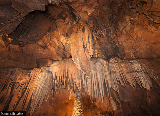
Mammoth Lakes
Surrounded by some of the highest peaks in the west, folks in this laid-back mountain town know they’ve got a good thing going. It’s a land of serious outdoor lovers, who take to the slopes of signature Mammoth Mountain (actually a massive volcano surrounded by granite peaks) and nearby June Lakes resorts in winter, then head out on trails when the snow melts to fly-fish in clear mountain streams, hike and mountain bike through wildflowers in high alpine meadows, and dip into natural hot springs.
In winter, Mother Nature is good to Mammoth Lakes. The mountain town’s signature peak, Mammoth Mountain, gets, on average, more than 30 feet/9 meters of snow, and lifts and gondolas continue to zoom up the mountain longer than any resort in the state. Visit the base village for shops, restaurants, and nightlife. Even if you’re not a skier, you can take advantage of Mammoth Mountain’s gondola, which climbs to the mountain’s summit at 11,053 feet/3,369 meters for jaw-dropper views of surrounding high-altitude peaks.
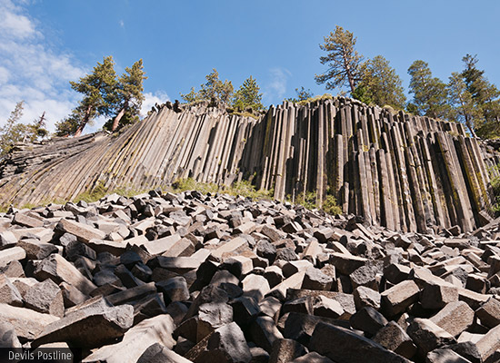
Devils Postpile
Follow Highway 203 west of Mammoth Lakes through stunning mountain scenery to explore this remarkable natural wonder. Looking like lumber pile left over by the gods, the 60-foot/18-meter basalt columns at this National Monument induce a lot of head scratching and pondering. How did these flawless columns get here anyway? Truth is, they formed on site, the result of volcanic eruption that sent lava flowing down the mountainside here, leaving behind an impressive wall of columns. Glaciers played a part too, exposing the columns and naturally polishing and enhancing the lava’s natural hexagonal patterns.
No matter how they were created, these columns are cool, and well worth exploring, as are other sites here. Follow the 2.5-mile/4-km trail to breathtaking 101-foot/31-meter Rainbow Falls. Also check out current evidence of volcanic activity at the monument’s soda spring area.
In summer (mid-June through Labor Day), driving into the park is restricted, but it’s easy to catch the shuttle from Mammoth Lakes. In winter, roads are generally closed, so you’ll need to cross-country ski or snowshoe into the park. Other times of year it’s okay to drive in: just know that the parking lot often fills by mid-morning on sunny days and weekends, so get there early.
If you arrived via shuttle, return to Mammoth Lakes to continue your itinerary. If you drove in by car, return to I-395 and continue south to Manzanar National Historic Site, an enlightening reminder of what happened here during World War II.
Manzanar National Park
Driving south along I-395, the landscape is staggeringly beautiful—giant peaks to the west, dramatic high desert plains and hills to the east. Just south of the tiny town of Independence, turn in to this sobering glimpse of what happened in the region back in the 1940s. During World War II, thousands of Japanese-Americans were moved from their homes throughout the West and brought to internment camps like Manzanar. This remote site in the wind-swept Owens Valley aims to shed light on that time and the people who lived here, through recreated buildings, photographs, films, oral histories, and interactive displays. Today you can sort through layers of history at the Manzanar Visitor Center, where some 8,000 square feet/743 square meters of exhibits relay a fascinating, albeit disturbing, part of California’s history. Next on the trip is a stop at Mt. Whitney, the tallest mountain in the 48 contiguous United States.
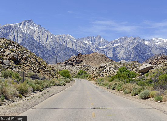
Mount Whitney
From Manzanar south on I-395, you’ll probably have a hard time keeping your eyes on the road. That’s because you’ll want to stare west and up, up, up at some of the tallest mountains in the country, so tall that clouds hover below their summits, so high in the night sky that they block out stars. And among these giants is this granite beast, topped by a hornlike granite formation near its summit, which scrapes the sky at 14,494 feet/4,418 meters, making it the tallest mountain in the 48 contiguous states.
The Sierra quickly dwindles south of Mt. Whitney, and your route swings west then north around the southern end of the mountain range to head north again, leading you to Sequoia & Kings Canyon National Parks and the largest living things on earth.
Sequoia Kings & Kings Canyon National Parks
Climb back into the Sierra, this time on the mountains’ west side, to explore this expansive and diverse parkland. Famous for their giant sequoias, soaring mountains, deep canyons, and roaring rivers, this tandem set of parks have plenty to see, even though they are less well known than Yosemite, roughly 120 kilometers north. Thanks to the General Sherman Tree, the world’s largest living thing, and its gargantuan neighbors, gawking at the big trees is the most popular activity here. The General Sherman Tree measures 31-meters around, and soars 84 meters into the blue Sierra sky—and it’s still growing. Every year it adds enough wood to make another 60-foot/18-meter-tall tree. Still can’t grasp the size? One branch of the General Sherman is so big—almost 7 feet/2 meters in diameter—that it’s larger than most trees east of the Mississippi River.
Not surprisingly, General Sherman attracts a crowd, which is why the park runs free summer shuttle buses to two separate stops, one above and one below this amazing tree. Many visitors get off at the upper stop and walk one-way downhill to the lower stop, passing the General Sherman along the way. Winter snows significantly limit access in the parks; check the website in advance for details. From here, your road trip continues north to another crown jewel of California, Yosemite National Park.
Yosemite National Park
The route north of Sequoia & Kings Canyon National Parks takes you through deep forests on the Sierra Nevada’s west side, then drops to the sweeping agricultural farms of the Central Valley before climbing east again into the mountains. Here lies Yosemite, California’s first national park and designated as a UNESCO World Heritage site in 1984. Yosemite attracts 4 million visitors each year—with good reason. Nearly the size of Rhode Island and covering more than 1,100 square miles/284,899 hectares, it features unforgettable natural beauty, from the sheer walls of Yosemite Valley to the alpine beauty of Tuolumne Meadows.

Among Yosemite’s many bragging rights, its waterfalls rank high. In the list of the world’s 20 tallest waterfalls, Yosemite Valley scores three spots for Yosemite Falls, Sentinel Fall, and Ribbon Fall. Yosemite Falls holds the undisputed title of the tallest waterfall in North America. It’s a challenging hike to the top of the 2,425-foot/729-meter falls, but fortunately it’s an impressive view from the base to—an easy and scenic 1-mile/1.6-km loop that should be on everyone’s bucket list.
One of the most photographed regions of Yosemite, Tuolumne Meadows is a wide, grassy expanse bounded by high granite domes and peaks. From its tranquil edges, hiking trails lead in all directions—to the alpine lakes set below the spires of Cathedral and Unicorn Peaks, to a series of roaring waterfalls on the Tuolumne River. From Yosemite, continue north to your last stop, a visit to the outstanding and easily accessible groves of giant sequoias at Calaveras Big Trees State Park.
This road trip was provided by Visit California
If you would like to book car hire or motorhome rental in USA, simply use our online booking engine above or contact our friendly reservations staff.
Road Trips Search
Categories
- Home
- Road Trips
- Sierra Adventure